Earthquake in Venezuela (Jun 2026)
On 24 June 2026, a strong seismic doublet was publicly reported in north-central Venezuela, near the Caribbean coast west of Caracas. This recent event may be useful for the GEP community as a starting point for EO data discovery, surface displacement analysis, and workflow preparation around earthquake-related deformation and damage assessment. For public context, users can refer to the Disaster Charter activation page and the USGS event page for the M7.5 earthquake near Yumare.
The public activation page includes several reference products, including surface displacement, radar mapping, building impact and infrastructure damage examples. These should be treated as external public reference material, not as GEP outputs.
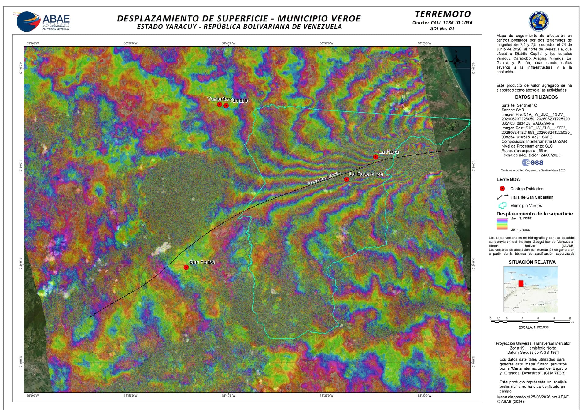
Image: Surface displacement product over Municipio Veroe, Venezuela. Source: Disaster Charter public activation page / ABAE. Credit: ABAE / Disaster Charter public product. Product shown as a public reference example, not as a GEP output.
This topic presents preliminary GEP visualisation examples based on InSAR products generated with the DInSAR — DInSAR Displacement Mapping and SAR Features services. The screenshots below introduce the type of information being prepared, including interferometric phase, coherence and line-of-sight displacement layers from Sentinel-1 data.
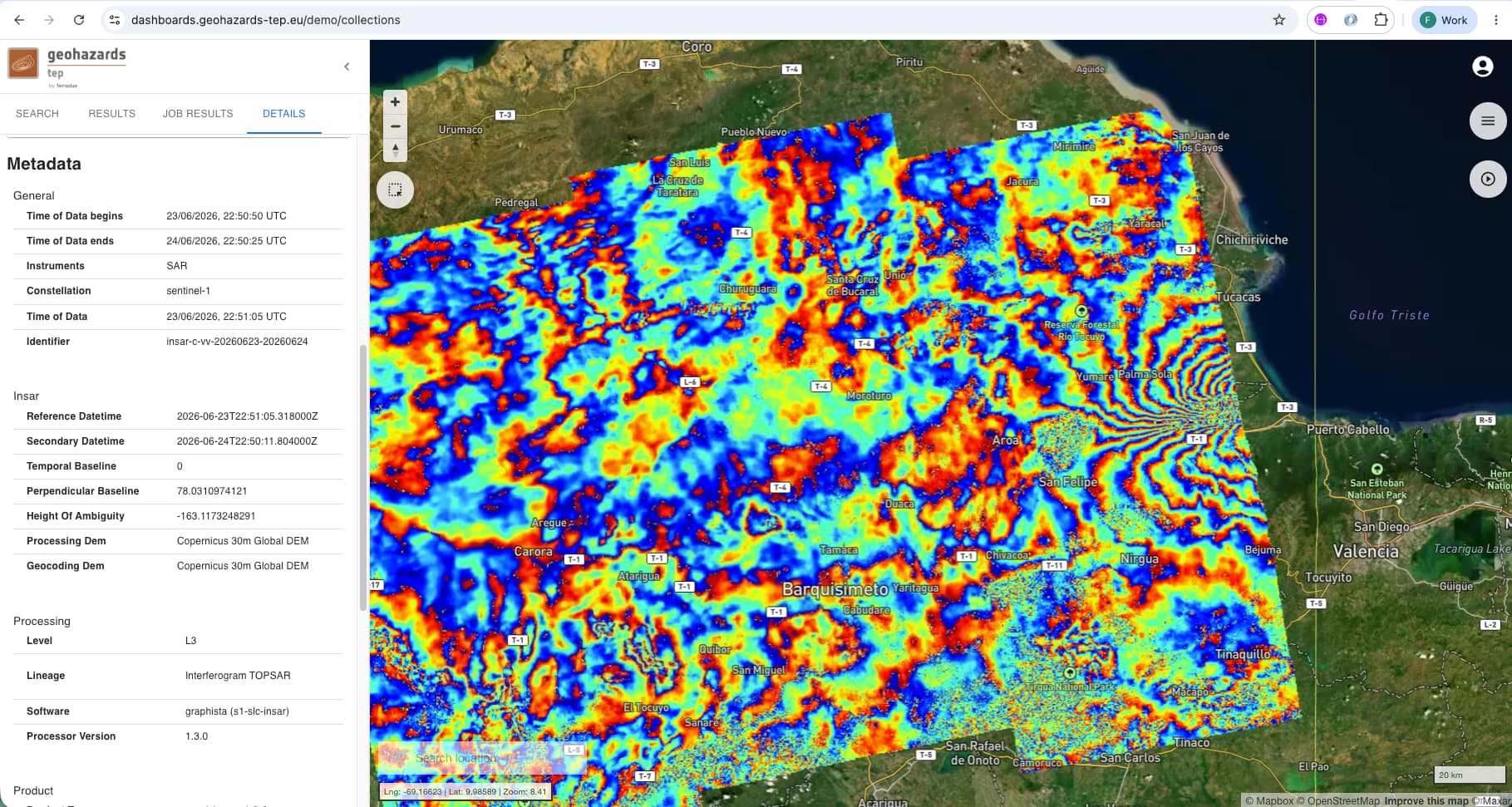
Image: GEP DInSAR product over north-central Venezuela, showing an interferometric phase layer derived from a Sentinel-1 interferometric pair acquired from relative orbit 106, ascending. Reference image acquired on 23/06/2026 and secondary image acquired on 24/06/2026. This product contains modified Copernicus Sentinel-1 data 2026 processed with the GEP DInSAR service. Screenshot prepared by the operator for this topic. [ Download ]
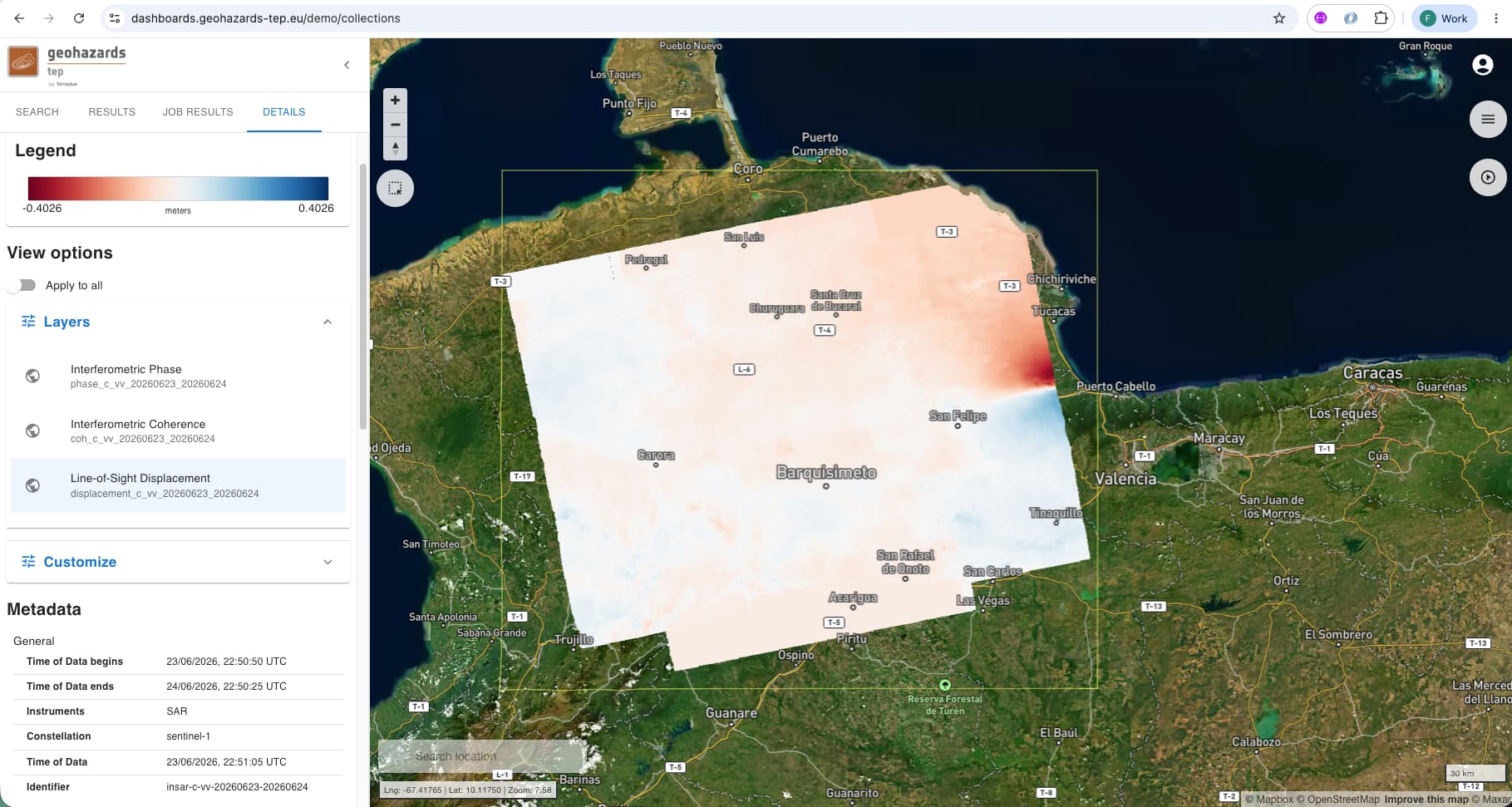
Image: GEP DInSAR product over north-central Venezuela, showing a line-of-sight displacement layer derived from a Sentinel-1 interferometric pair acquired from relative orbit 106, ascending. Reference image acquired on 23/06/2026 and secondary image acquired on 24/06/2026. This product contains modified Copernicus Sentinel-1 data 2026 processed with the GEP DInSAR service. Screenshot prepared by the operator for this topic. [ Download ]
The DInSAR workflow can support interferometric analysis from Sentinel-1 SLC pairs, including coherence, interferometric phase and line-of-sight displacement products. For earthquake events, these layers can help users explore where surface displacement may be visible, where coherence is reduced, and where further interpretation may require comparison with geological, seismological or damage-assessment information.
The SAR Features workflow supports automated detection of surface changes from Sentinel-1 coherence and backscatter data. For disaster events, the resulting maps can help users identify areas where damage-related change may be present, complementing other geospatial and field-based information.
Relevant GEP services
These services may be a useful starting point for preparing EO workflows around this event:
- DInSAR — DInSAR Displacement Mapping — interferometric analysis from Sentinel-1 SLC pairs, including coherence, phase and line-of-sight displacement products.
- SAR Features — provides a detection of changes using co-pol sigma nought and coherence from two Sentinel-1 SLC image pairs acquired before or after an event.
A practical first step is to review Sentinel-1 acquisitions before and after the 24 June 2026 earthquake, check whether the acquisition geometry supports interferometric analysis, and compare the resulting phase, coherence and displacement layers with public earthquake information and external reference products. Binarizing negative coherence-difference values can be used as an exploratory proxy to highlight possible damage-related change in built-up areas, but such results should be interpreted with caution and compared with independent information.
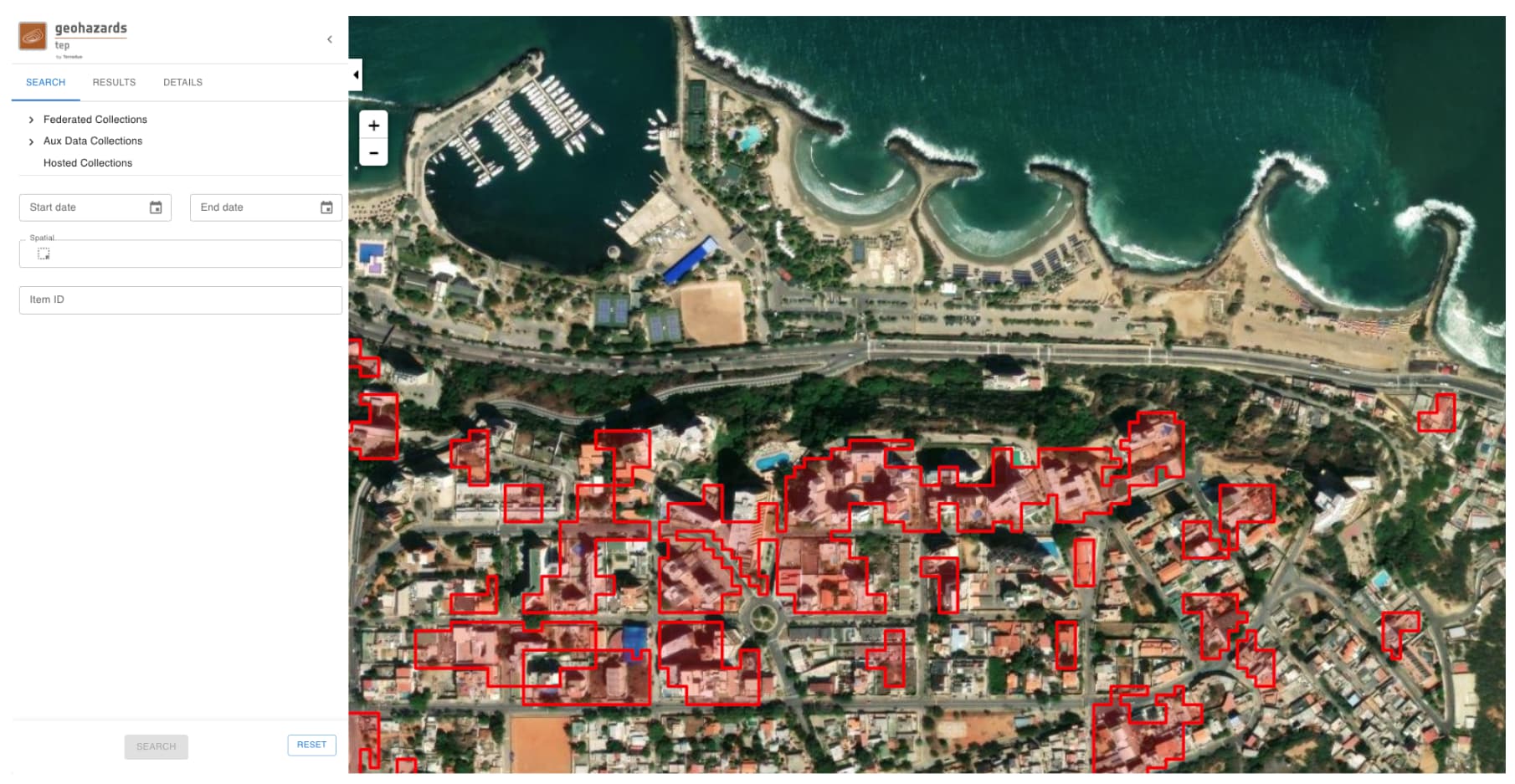
Image: Result from the binarization of the difference between co-seismic and pre-seismic interferometric coherence over DLR WSF 2019 built-up areas, derived from Sentinel-1 SLC data in ascending orbit state and relative orbit 33 over the area of Caracas, Venezuela. Areas highlighted in red are where coherence difference is lower than -0.5. This product contains modified Copernicus Sentinel-1 data 2026 processed with the GEP SAR Features service. Screenshot prepared by the operator for this topic.
The same result files can also be opened in the GEP analysis environment. The example below shows selected DInSAR outputs made available from GEP Drive and visualised in the QGIS Remote Desktop, which can be useful for users who want to inspect the layers directly, combine them with other geospatial data, or continue the analysis in a familiar desktop GIS interface.
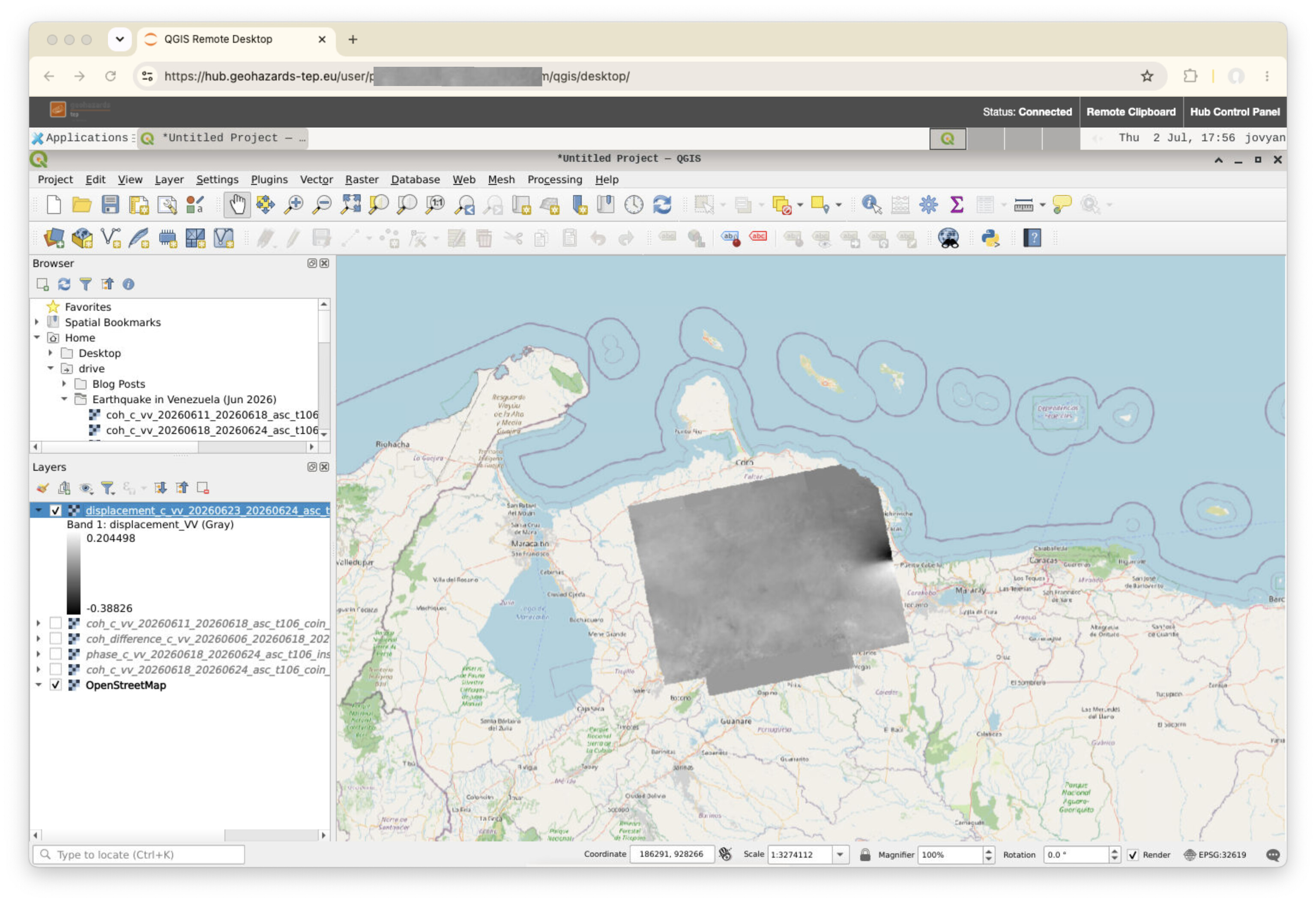
Image: GEP DInSAR outputs for the Venezuela earthquake opened from GEP Drive in the QGIS Remote Desktop environment. Source: GEP screenshot prepared by the operator for this topic.
Selected screenshots are shown here as preview material. Full-resolution product sharing and public browser access are being reviewed and will be clarified as the event page is updated.
Scientific Context
For additional scientific context, the FRINGE 2026 abstract “Sentinel-1 InSAR Reveals Complex Strain Accumulation at the Southwestern Caribbean-South America Transform Plate Boundary”, by Machel Higgens, Shimon Wdowinski and Omar Perez, discusses Sentinel-1 InSAR analysis of northern Venezuela and the Southwestern Caribbean–South America transform plate boundary. This provides useful background for interpreting regional deformation patterns, although the GEP products shown here are event-focused and should be read together with public earthquake and damage-assessment information.
Further information
This topic may be updated as additional GEP products, screenshots or notes become available. To follow the discussion, use the Watching button below the post and you will be notified when new information is added.
This topic is shared for community awareness, EO data discovery, and workflow preparation. It is not an official emergency response communication and does not imply that GEP produced the public reference products or is providing operational emergency response support.