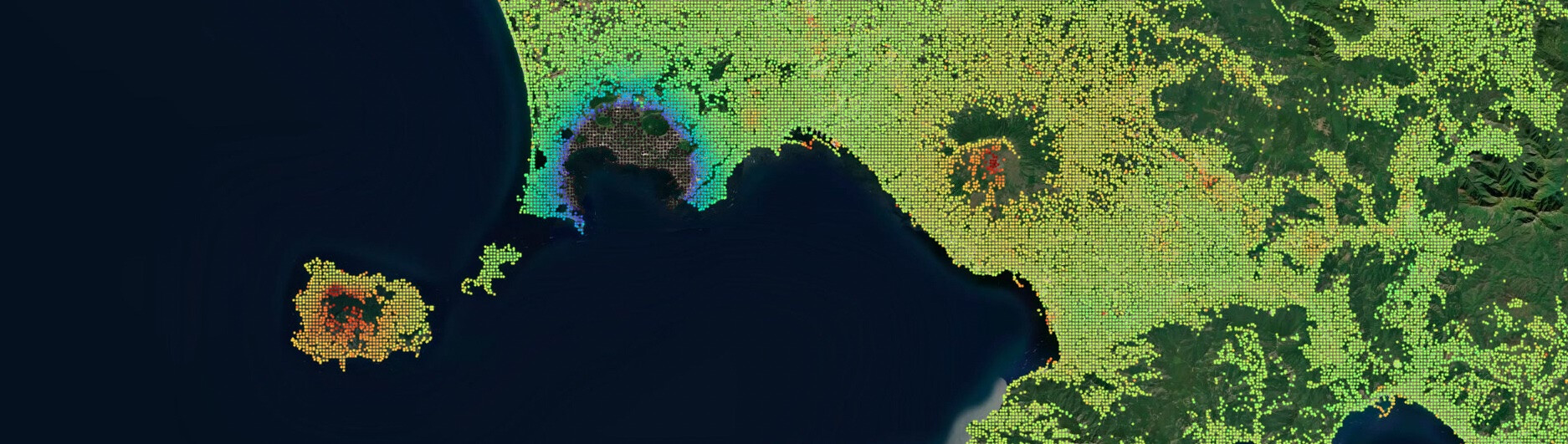
The Geohazards Exploitation Platform (GEP) is proud to announce the availability of the updated European Ground Motion Service (EGMS) Ortho Vertical (Level 3) dataset on the platform, covering the reference period from 2018 to 2022. The EGMS is part of the Copernicus Land Monitoring Service product portfolio, which is implemented by the European Environment Agency (EEA) within the EU Copernicus programme.
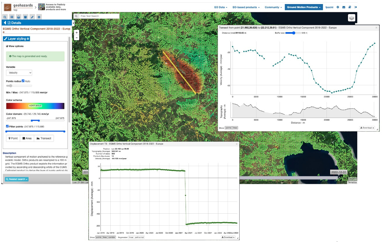
Figure 1: Example of time series plotting for point and transect in the area around Tirnavos in Greece.
Ground motion is typically caused by earthquakes, volcanoes, landslides, and land subsidence and includes deformations concerning infrastructures such as transportation network or constructions. Monitoring these movements is crucial for assessing relevant risks and managing natural disasters. Released on an annual basis, EGMS products, such as the Ortho Vertical velocities, are historical terrain motion mapping products at high resolution that provide unprecedented insights into these phenomena, enabling better preparedness and response strategies.
The EGMS is an Earth Observation (EO) based product providing ground motion measurements on an annual basis over the territories of contributing countries of the European Union. EGMS products, based on data from the Copernicus Sentinel-1 mission, are available with open and unrestricted access. The publication of the EGMS Ortho product on the GEP represents a significant milestone, offering geohazard user communities with comprehensive access to data in a processing environment with advanced visualization and download capabilities. In addition to data access, the platform provides complementary services and tools that enable users to analyze data from a wide range of sources, including Copernicus Sentinel-1, Sentinel-2, Sentinel-3, and other EO missions.
This activity was facilitated by the collaboration between the European Space Agency (ESA) and the EEA with the goal to increase the awareness, acceptance, and adoption of EO-based terrain motion products in Europe.
The idea with the publication of EGMS Ortho product on the GEP is two-fold: for one, it allows user to access advanced products seamlessly, online, and in a smart fashion. At the same time, it supports tailored analyses using a range of complementary EO-based processing chains, optical and radar, available on-demand on the GEP. Annual terrain motion measurements from the EGMS can be complemented using a range of products to be generated on-demand based on advanced InSAR chains (such as P-SBAS provided by CNR IREA or SNAPPING PSI provided by Aristotle University of Thessaloniki) alongside with terrain motion services using Optical data (such as the GDM-OPT service of CNRS EOST).
With the publication of EGMS products on the GEP the following is provided:
- Persistent access to free and open data from Copernicus EGMS: One of the primary objectives of the activity is to provide the geohazard user community with an alternative access point to selected EGMS products. These products are offered free of charge, reflecting a commitment to open science and to the democratization of data.
- Enhancing understanding and promotion of geohazard products from different sources: Publishing EGMS products alongside with other geospatial products available on the GEP helps improving the understanding of terrain motion phenomena and promoting their significance to a wider audience. This is achieved by providing access to not only EO data but also to non-EO data, and by allowing the user or Third Parties to upload in-situ data, GNSS measurements, auxiliary geospatial data etc. directly to the platform. Users can perform inter-comparison, technical validation, apply post-processing tools that help retrieve added value information.
- Enabling downstream applications: The GEP aims to support the user communities by enhancing the usability of EGMS products with a suite of online processing services and analytical tools hosted on the GEP. The integration of complementary data processing chains, including those from radar and optical EO sources, allows more comprehensive geohazard analyses. Users can also retrieve actionable insights, which are crucial for planning and decision-making in various sectors.
Accessing EGMS products through the GEP provides several key features implemented on purpose to support geospatial data analysis:
- Dynamic visualization: Users can visualize the average velocity of ground movements in a dynamic fashion on a map, enhancing the understanding of spatio-temporal patterns. Measurement points are automatically clustered in space according to the visualization scale.
- Customizable data representation: Through layer selection, look up tables and color scale adjustments, users can tailor the data presentation to meet specific analytical needs.
- Advanced data filtering: The dataset allows for filtering points according to velocity thresholds, facilitating focused analyses on areas of interest.
- On-the-fly time series visualization: Users can interact with the geo-browser and plot displacement time series for specific points, generate statistics for areas of interest, and visualize mean velocity values and surface elevation values along geographic transects.
- Export of time series data: Users can export the time series of terrain motion measurements on the map over the area of interest (and not full tiles). They can be saved in CSV format and in CovJSON format. Through simple auto-registration users can also download original tiles of the EGMS Ortho product.
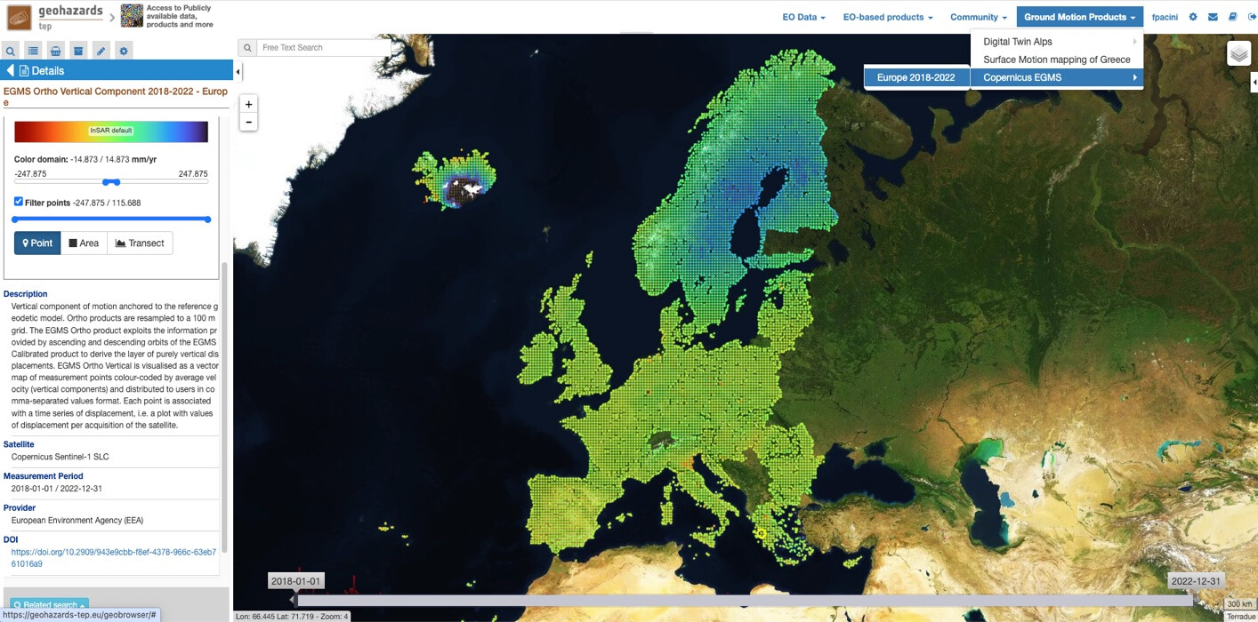
Figure 2: EGMS Ortho Vertical dataset available in the GEP public workspace. Concerning access to data from the Copernicus Land Monitoring Service (CLMS) please refer to data use terms and conditions.
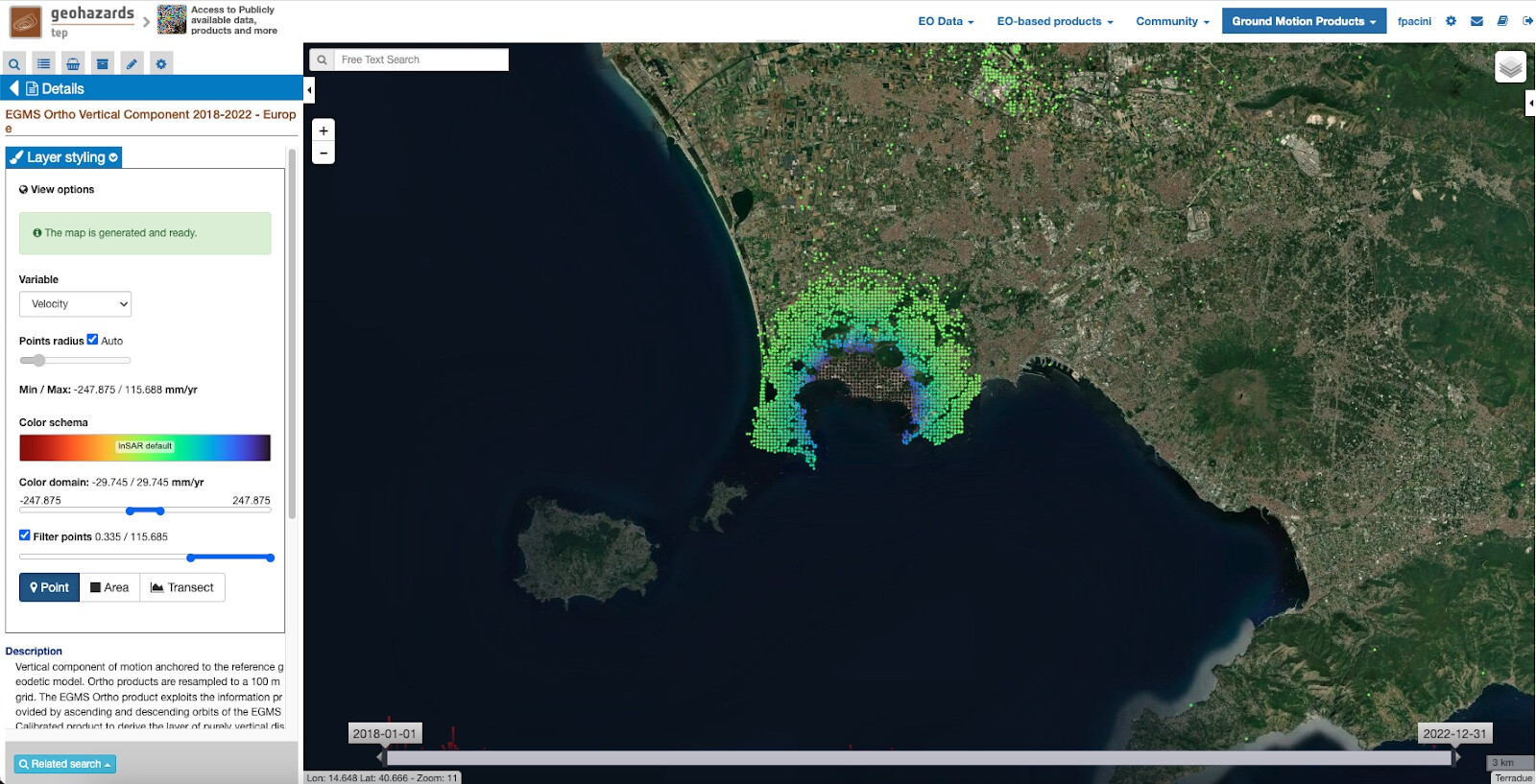
Figure 3: Example of map visualization filtered according to a velocity threshold (> 0.3 mm/yr) in the area of Campi Flegrei in Italy.
The EGMS Ortho Vertical dataset can be accessed via the newly introduced Time Series Viewer offered in the Public Workspace among the GEP Ground Motion Products (see « Ground Motion Products > EGMS > Europe 2018-2022 » on the upper right menu). Registered GEP users can also download the original dataset tiles in CSV format.
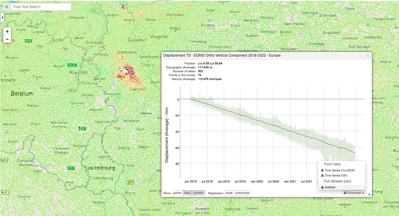
Figure 4: Time Series for a selected point or AOI can be exported in CSV and CovJSON formats. The related original EGMS Ortho Vertical tile can be also downloaded.
With today’s release of the full EGMS Ortho Vertical dataset on the GEP, efforts have been applied to implement a method for seamless visualization and download with Cloud optimized standards. It should be noted that access to this resource is guaranteed for the next two years thanks to a sponsorship granted by ESA. Publishing updated EGMS products might be considered in the future depending on the availability of processing and storage resources. This will allow researchers, planners, and environmentalists to try the solution and to leverage the functionalities in time for relevant projects.
The integration of the Copernicus EGMS Ortho Vertical into the GEP is a significant advancement towards building an information- and tools-rich ecosystem. This ecosystem is designed to empower users by providing:
- Broad Access to Data: Users will have unrestricted access to regional and global-scale datasets, which are critical for comprehensive geohazard analysis and environmental monitoring.
- Advanced Services and Tools: The GEP offers both free and commercial services, including advanced techniques such as advanced Persistent Scatterer Interferometry, which allow users to enrich and update ground motion measurements as an on-demand service over a region of interest. While EGMS products are released annually this is instrumental in maintaining the currency and relevance of data analyses.
- Methodological and Visual Data Comparisons: Users can perform comparisons of products obtained through different methodologies and algorithms. By integrating both SAR and optical EO data, the platform facilitates a deeper understanding and cross-validation of results, enhancing the reliability of interpretations.
- Value-Added Product Development: The available post-processing tools on the GEP enable users to derive value-added products, further enhancing the utility of the EGMS dataset in real-world applications.
GEP is preparing innovation and new developments and as its EO service portfolio evolves it is anticipated that it will play a pivotal role in shaping new solutions for geohazard risk applications.
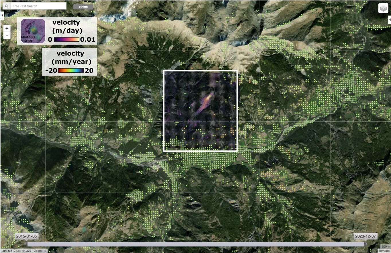
Figure 5: Illustration of the complementarity between the Sentinel-1 based EGMS products and products generated using on-demand services on the GEP. This example shows terrain motion products generated using the Sentinel-2 based GDM-OPT-Slide service over the La Valette landslide in France (delimited by the white insert in the picture). EGMS products provide ground motion measurements (colored dots) in particular over urban and peri-urban land and in areas with relatively slow displacements (<1m/year) while products generated using the GDM-OPT-Slide service (white to purple area in the insert) can be used to monitor faster motion (>0.01 m/day) thanks to the image matching technique using Sentinel-2 Optical data. Products in the figure are also available in this data package.
Researchers, industry professionals, and enthusiasts are invited to explore the rich possibilities offered by the Copernicus EGMS products. By participating in the GEP community, users can contribute to, and benefit from, collective efforts to advance the understanding of geohazards. For further details, access to the community forum, and additional resources, please visit the GEP website.
Sponsorship and Support by the Network of Resources (NoR)
The GEP operator acknowledges the sponsorship and support provided by the Network of Resources (NoR) concerning the availability of the EGMS Ortho Vertical dataset. The NoR plays a crucial role in facilitating access to satellite data and promoting the use of space-based resources across various scientific and commercial projects.
The NoR sponsorship program aims to enhance the capabilities of organizations and individuals by providing tailored support for the utilization of space assets and resources. This program is instrumental in fostering innovation and accelerating the development of applications that leverage Earth Observation data. For more information about how the NoR supports projects like ours and to explore opportunities for sponsorship, please visit the NoR Sponsorship page.